
When you head out on the water for a day of paddling, a GPS is one of the most important safety tools you can bring with you. Even if the weather is sunny and clear when you head out, fog can move in quickly and make it hard to navigate home. Plus, a GPS can help you see what’s around you as you paddle, so you can always find sheltered areas and explore new routes.
In order to help you find the best GPS for kayaking, we considered a number of features. First, we looked at different types of GPS units – some are simple GPS receivers, while others include a fishfinder that is perfect for anglers, charting software for exploring, or a VHF radio for emergency communications. We also considered the display of different units to make sure they are easy to read and operate. Battery life was another important consideration, as was the type of satellite coverage, since both affect whether you’ll be able to use your GPS when you need it. And finally, we made sure all the options are waterproof or at least water resistant.
We spent tens of hours researching technical specifications and user reviews for popular kayaking GPS units. The result is our list of the seven best GPS trackers for kayaking in the table below. Continue reading for detailed reviews of each GPS, complete with pros and cons. Our buying guide covers everything you need to know about how to choose a GPS device that’s right for your style of kayaking. Finally, we sum up our three overall favorite GPSs for kayaking on the market today.
More features: 8GB internal memory, high-speed USB and NMEA 0183 compatible, Bluetooth and ANT+ compatible
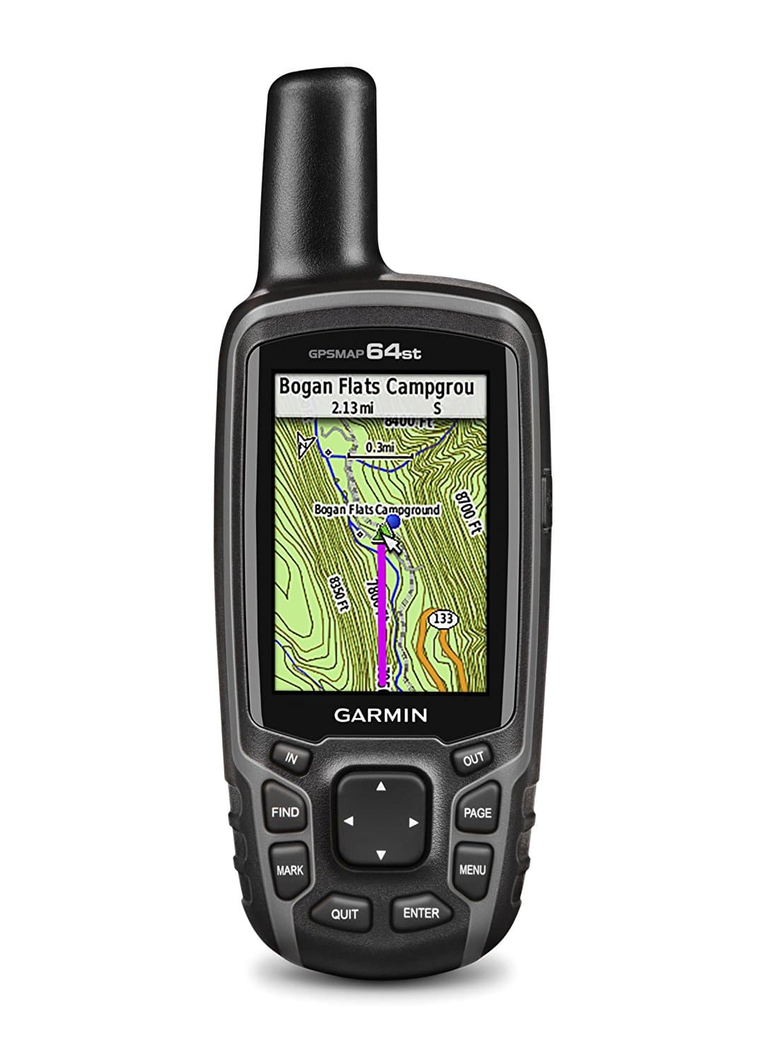
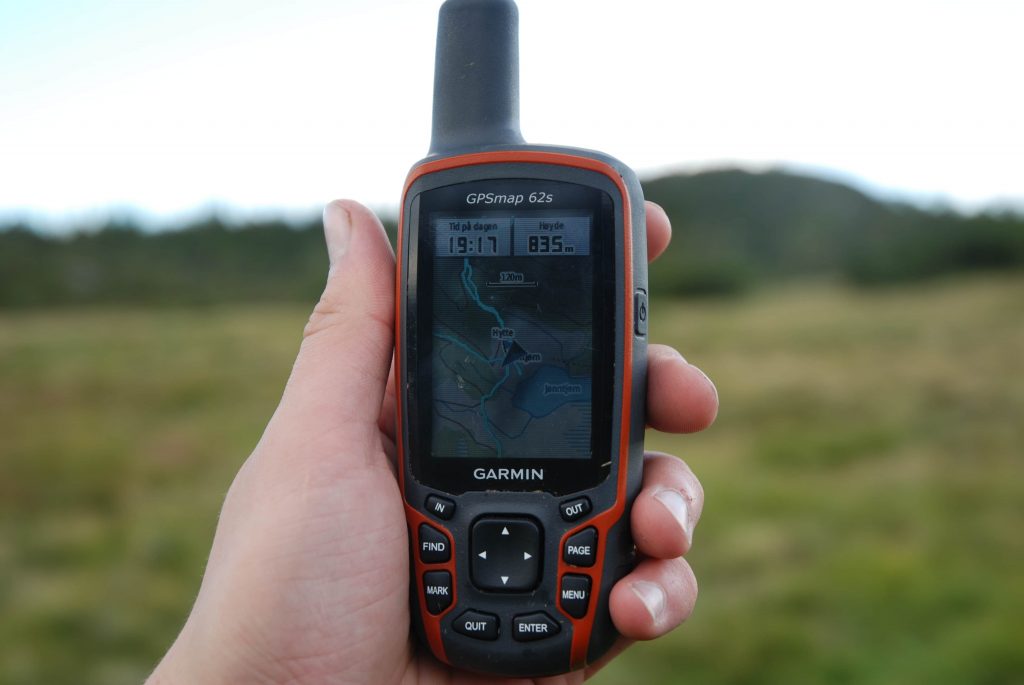
This high-quality handheld GPS for kayaking from Garmin includes virtually all of the features you need to plan a complex paddling trip. The device comes pre-loaded with 100K TOPO maps for the US and surrounding waters, and Garmin’s BaseCamp software makes it easy to download additional maps to the unit’s 8 GB of internal memory. The GPS is also compatible with Bluetooth and ANT+, so you can easily add waypoints and track markings on the go from your smartphone.
The high-resolution screen is not huge, at 2.6 inches, but users found that it was more than sizable enough to read easily. They also appreciated the adjustable brightness, which made it possible to see detailed navigational information even in bright sunlight conditions.
Other useful features on this GPS include a 3-axis tilt compass, which you can use in lieu of a standard waterproof compass for navigating along a heading. The GPS also has a built-in barometer, which can be used to detect if storms are approaching. A helpful feature for the most rugged adventures is that this device uses both GPS and GLONASS satellite networks, so you’re likely to have coverage no matter where you go.
Users also appreciated that despite having all of these features, the GPS is designed to be user-friendly. They found that it was easy to track a kayaking route and to store waypoints along the way. Plus, with 10,000 custom waypoints and up to 200 stored routes, users noted that they never had to delete data in the middle of a paddling season.
More features: 3.7GB memory, HotFix satellite prediction
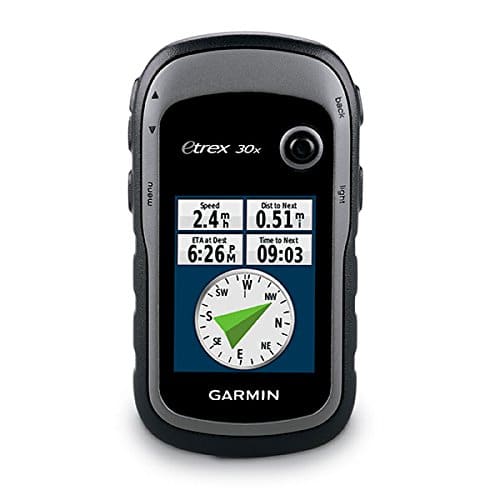
In many ways, the eTrex 30 is a smaller version of the GPSMAP 64st handheld GPS for kayaking. It features the same 3-axis tilt compass and barometer, as well as has the ability to access both the GPS and GLONASS satellite networks. Plus, it can store up to 10,000 points and 200 saved GPS tracks.
Where the eTrex 30 reduces cost and size compared to its larger cousin is in the screen. The display is just 1.4 by 1.7 inches, which can be problematic for kayaking if you want to mount the unit on the front of your boat – to see map details, you’ll likely need to hold it up to your face. The GPS also places the buttons on the side and has fewer of them, which can make navigating through the menus on this device somewhat trickier than on the GPSMAP 64st.
In addition, the eTrex 30 has just 3.7 GB of internal memory, although most users didn’t find this to be a problem since it also has a microSD card slot for loading additional maps. The GPS is Bluetooth-compatible so you can share route data with your phone and is fully supported by Garmin’s BaseCamp software if you want to create custom map sets and route markers ahead of your trip.
The main downside to this GPS unit is that it doesn’t come with pre-loaded maps for the US, but rather a simple low-resolution base map for the entire world. This means that you’re likely to need to purchase the TOPO 100k or TOPO 24k map set separately.
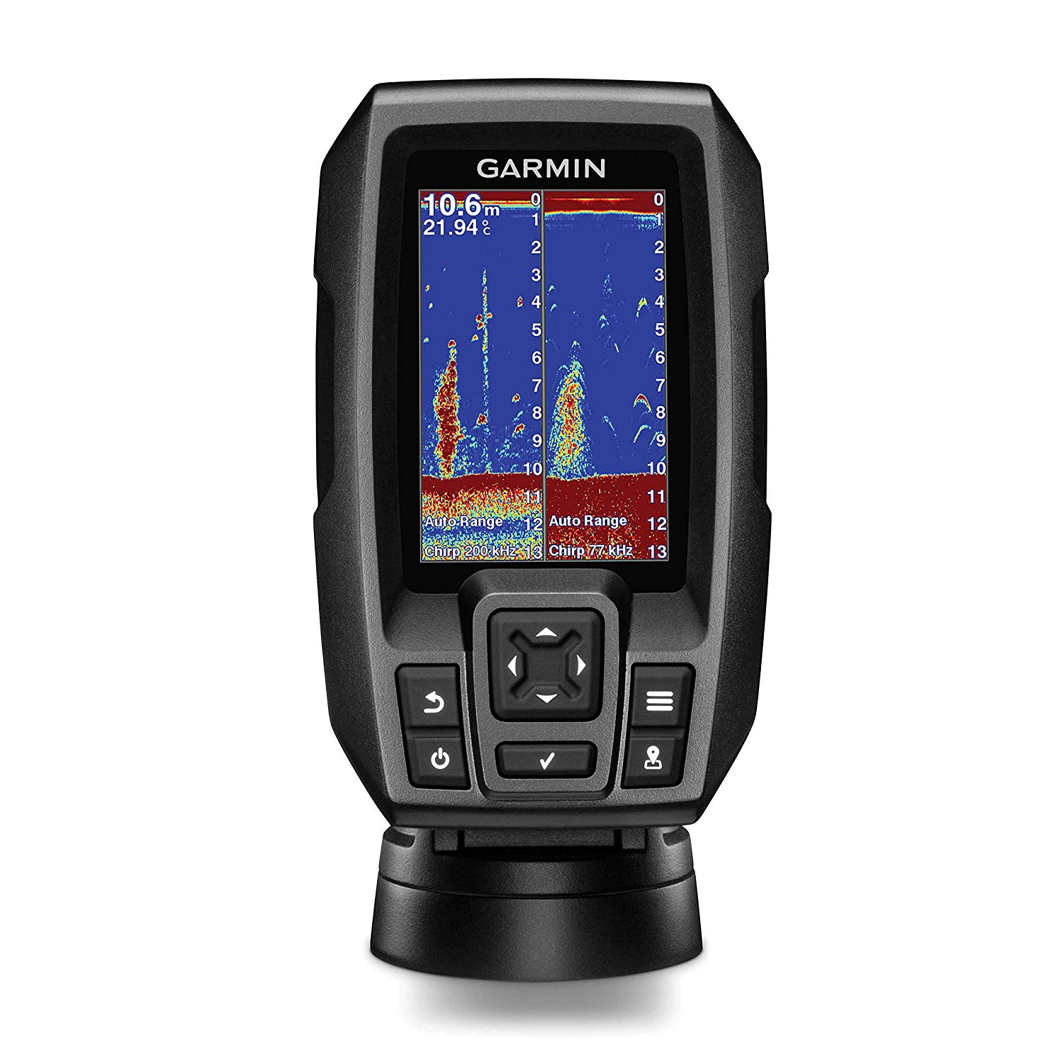
More features: CHIRP Digital Sonar, DualBeam PLUS, XNT 9 20 T transducer
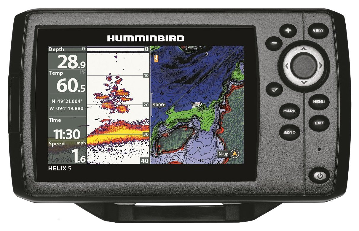
This fishfinder GPS combination is designed for small boats like a kayak, with a 5-inch diagonal display that is easy to see when the unit is mounted on the front of your boat. Even better, the GPS unit comes with a mounting bracket to help you get started. The Helix 5 comes pre-loaded with charts for most US lakes and coverage for anywhere you could access along the US coast, which means that it’s good to go out of the box for most users. If you want to take this GPS further afield, there is a microSD card slot that allows you to add additional maps and waypoints.
Another feature specifically aimed at anglers who frequently paddle in the same area is Humminbird’s AutoChart Live. This uses the built-in sonar in the fishfinder as a mapping tool, recording the bottom hardness and vegetation – which affect where fish will be hiding. You can record for up to eight hours on a single battery.
One of the primary advantages of the large screen size on this GPS is that it is possible to show the fishfinder display and the map display side-by-side. That way, you can make sure you’re paddling in the right direction even while you’re keeping an eye out for potentially good fishing spots.
Note that some users did report issues with the construction of this GPS device. While the GPS is rated to IPX7, multiple users found that the plastic clips used to hold the battery in place would repeatedly fail, turning the unit off suddenly or preventing it from turning on at all.
More features: high-speed USB and NMEA 0183 compatible, 1.7GB memory, HotFix satellite prediction
This rugged and compact handheld GPS for kayaking is another great navigational tool from Garmin. The device is specifically tailored towards water navigation, since it is designed to float when dropped overboard. Another small but important advantage to this GPS is that it uses two AA batteries, which can easily be replaced at any time if you’re out for a longer trip.
The GPS comes only with a world basemap, which isn’t very useful for navigating. So, you’ll need to purchase additional maps for most uses – a microSD card slot allows you to add custom maps from Garmin’s BaseCamp software or to plug in BlueChart g2 preloaded map cards that cover most coastal areas and lakes. Note that the GPS has only 1.7 GB of internal memory, so you will need to largely rely on the microSD card slot for maps.
The screen on this GPS is quite small, so you’ll need to hold it up to read it rather than mount it on the front of your GPS. In addition, while users liked the navigational buttons on the top of the GPS, they noted that their placement makes it difficult to move through the mapping software without obscuring the screen with your hand.
That said, the GPS also has a few additional features that users appreciated. These included a 3-axis compass and a barometer for detecting oncoming storms. You can also load a massive 10,000 waypoints onto the GPS, so you’ll never lose track of a favorite spot.
More features: 66-channel WAAS GPS, DSC calling, position sharing, waypoint and route navigation
This combination VHF radio and GPS is a great choice for ensuring your safety if you’re on a long-distance kayaking trip through open water, such as when sea kayaking. This device is the only GPS we reviewed that is rated to IPX8, an indicator of how rugged it is in any conditions.
This tracking device resembles a radio much more than a standard GPS unit thanks to the boxy shape and large antenna. The display is rather small and is not designed to display maps. Instead, it simply gives your coordinates and can be used for basic directional navigation to a waypoint. The GPS is capable of entering and saving up to 200 waypoints and 20 routes, so you’ll likely want to clear the memory cache after each trip.
One of the unique features of this device relative to other GPSs is that you can see what ships are around you. The Group Monitoring feature actually shows up to nine vessels, typically large boats, that are near your kayak. This can be extremely helpful if you ever do need to radio to a nearby ship for help or to let them know you are there.
In addition, the VHF functions of this GPS mean that you have access to NOAA’s maritime weather report and weather alert system. For longer trips with changing weather conditions, this kind of information can be invaluable.
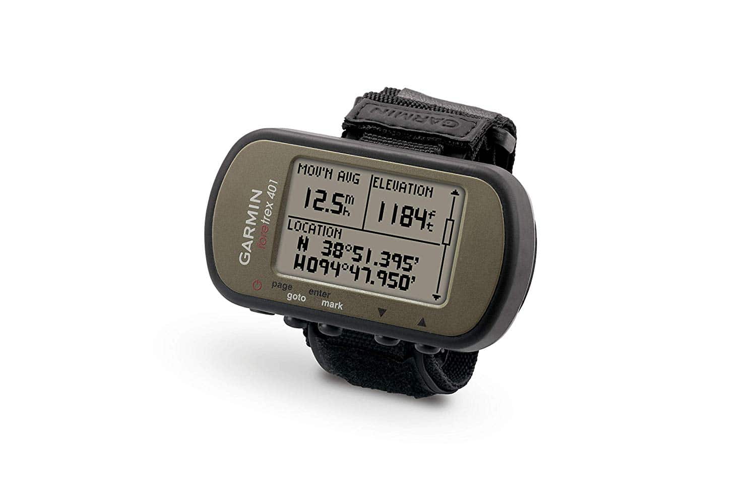
More features: TracBack® navigation, dual position readout
This GPS watch for kayaking from Garmin offers a huge amount of helpful information in a relatively small display. In addition to showing your positions in coordinates, the GPS keeps track of your route. If you want to paddle back the way you came, the screen will display your route as dots and help you stay on course using the TracBack navigation feature. The GPS also features a three-axis compass and barometer, which can provide additional useful navigational and weather information.
The backlight on the Foretrex 401 is one of the features that helps to put it ahead of the competition. The backlight makes it easy to read the display even in the dark, and can be set to go out between 30 seconds and several minutes.
Importantly, users felt that the GPS watch is also comfortable to wear. While the elongated shape and large size relative to many wrists may be initially concerning, users found that the watch was overall comfortable and does not interfere with the paddling motion. However, this GPS will likely not be something that you wear when out of the kayak.
The GPS uses two AAA batteries, which means it’s easy to carry spares and to replace the batteries in the middle of a trip if needed. Plus, the Velcro strap is highly secure and won’t allow the watch to fall off into the water while you’re paddling.
More features: CHIRP (77/200 kHz) sonar
This inexpensive GPS and fishfinder from Garmin is designed primarily as a sonar system, but can also be used as a backup navigational tool for kayaking anglers. The display is just large enough to see clearly when it is mounted on the front of your kayak – and a tilting and swiveling mount is included with the device. Note, however, that users found that the display was quite difficult to read in bright sunlight or when wearing sunglasses.
The navigational features are somewhat limited to waypoint navigation. You can see your position and the position of your waypoints as a route to follow, but there is no way to add base maps to this GPS so that you can get a sense of your surroundings. Some kayakers may appreciate the speed and time to destination displays, which give you a sense of how long your trip will take.
The sonar display indicates anything in the water and can be used to spot not only fish, but also bottom vegetation and soft spots that make good fish habitat. Overall, users were quite happy with the fishfinding capabilities of this device, and its depth range far exceeds the waters that most kayakers will be exploring – 1,600 feet in freshwater and 750 feet in saltwater.
Users also appreciated how simple and intuitive the device is to use. Most users reported being able to use the fishfinder and most essential navigation features without having to pore over the manual.
Now that you’ve learned more about the seven best GPS devices for kayaking, how do you choose the right GPS unit for your needs? Our Buying Guide will cover everything you need to know about the different types of GPS trackers, how you can use them, and what features you need to consider when choosing a GPS for kayaking.
All types of GPS devices for kayaking have their most important function in common: they use satellites to locate your position. Every GPS unit, regardless of the extra features it has, can give you your location in latitude and longitude so you can find yourself on a map or track your movement across a waterscape as you paddle.
However, GPS units can differ a lot in how they present that location information and the extra features they offer. GPS trackers for kayaking can be divided into several different types.
First, there are GPS devices that function purely as GPSs with built-in map screens. These models, like the Garmin GPSMAP 64st and eTrex 30x, are designed to not only locate your position, but also to show you where you are on a map of your area. These GPS devices are relatively simple to use, since they only have mapping functionality, and can be used to track your trip, pre-plot a course that you can follow, or mark points of interest along your route.
Some kayaking GPS devices, like the Garmin Striker 4 and Humminbird Helix 5, double as fish-finders. In addition to having a GPS receiver, these GPS + fishfinder devices also have a sonar system that attaches to the underside of your kayak to detect fish in the water below your boat.
For anglers, these units can be very advantageous, since they make it possible to see when fish are in the area of your kayak and what depths they may be at.
These fishfinder GPS units can do everything a standard GPS device can do, but they are typically limited to use in the water rather than on land as well. Note that some units, like the Garmin Striker 4, have GPS capabilities but no built-in maps.
For emergency situations, some GPS units have a built-in VHF radio. These GPS devices, like the Standard Horizon HX870, tend to provide only basic GPS functionality like giving you coordinates and directions to waypoints. But, having a VHF radio in your GPS means that it is easy to radio to other ships, including in an emergency, and to relay your location in coordinates.
Finally, GPS watches are among the most affordable and portable GPS devices. GPS watches for kayaking, like the Garmin Foretrex 401, do not give you built-in maps, but they do allow you to see your location, navigate to waypoints, and track your paddle in case you need to return along the same route.
 The display is one of the most important parts of any GPS unit since it’s where you’ll look for information. So, the display needs to be large enough, lighted enough, and high-resolution enough for you to make out information quickly without straining your eyes.
Handheld GPSs for kayaking tend to have relatively small displays to keep them lightweight and portable. However, because these GPS units also have high-resolution maps to display, they typically offer variable screen brightness, high screen resolution, and the ability to zoom in and out.
Fishfinder GPS systems often have larger screens since they are meant to be mounted on the front of your kayak. This larger screen can be helpful because you can split-screen the sonar display and any map or directional displays.
GPS watches unsurprisingly have the smallest displays since they need to fit on your wrist. Most often, like for the Garmin Foretrex 401, these displays are not in color, but use large fonts and have a backlight for viewing in low-light conditions.
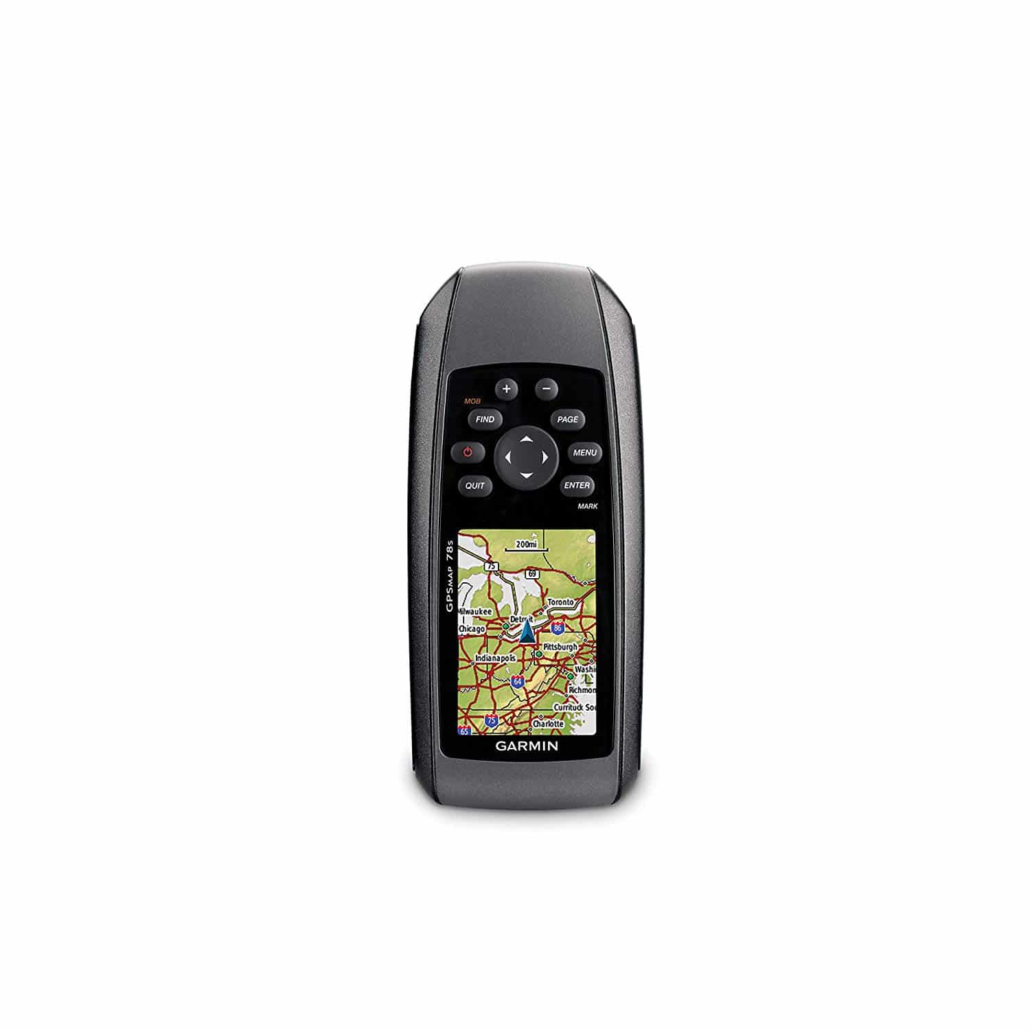
If your GPS has the ability to display maps, like the Garmin GPSMAP 64st, eTrex 30x, or GPSMAP 78S, you’ll need to consider where you’ll be kayaking. Some GPS units come with only maps of the US and surrounding waters, while other GPS units come fully loaded with maps for the entire world. Even then, the maps may or may not be at a high enough resolution for the purposes of your trip.
Most modern GPS units with mapping functionality allow you to download custom maps to your device using a USB or SD card.
Note that you may need to pay for map sets that are in the right format for your GPS, although Garmin has increasingly made it possible to add maps for free.
Kayaking GPS devices use a surprisingly wide range of battery types. For example, the Garmin Striker 4 requires a 12-volt battery, while the Standard Horizon HX870 requires a lithium-ion battery, while the Garmin eTrex 30 requires two AA batteries. When considering the type of battery, consider whether you’re likely to ever be out paddling longer than your GPS’s rated battery life – and if so, whether the given type of battery can easily be replaced in the field or purchased at any dock.
Battery life is a very important consideration, since you don’t want to be carrying tons of spare batteries even if you can replace them in the field. GPS devices are designed to last a surprisingly long time on a small amount of juice, so all of the units we reviewed have rated lives longer than 16 hours. Still, expect your GPS to run out of battery faster than this if you tend to keep the screen at maximum brightness or are viewing maps frequently.
 There are two different satellite location systems in use when it comes to GPS units: GPS and GLONASS. GPS satellites are run by the US and are slightly more accurate in most areas, while GLONASS satellites are run by Russia and have better coverage in polar regions.
Because GPS is US-run, all of the GPS devices we reviewed typically locate your position using GPS. However, the Garmin GPSMAP 64st and eTrex 30 can also use GLONASS satellites, making them slightly more versatile. Most paddlers won’t ever need to use GLONASS, so having a GPS-only device should not be a problem.
All of the GPS units we reviewed are rated to at least IPX7, meaning that they are fully waterproof even if you submerge them up to three feet deep for an extended period. This is more than enough protection to ensure that your GPS won’t fail because of water intrusion. Still, the Standard Horizon HX870 is rated to IPX8, which means that it can be submerged to more than three feet depth.
GPS devices for kayaking typically cost in the $100–$300 range, with the exact cost depending on the features of your GPS unit. Budget GPS devices and GPS watches can save you money, but don’t expect to get built-in map displays. On the other hand, GPS units with high-resolution map displays and powerful fish sonars will run on the high end of this price range.
Our three overall favorite GPS devices for kayaking are the Garmin GPSMAP 64st, Garmin eTrex 30x, and Humminbird Helix 5. The Humminbird Helix 5 is an ideal choice for kayak fishing since it combines an advanced GPS system with a high-quality sonar fishfinder. The unit comes with maps for most US waterways preloaded and can record sonar for up to eight hours to help you find the best fishing spots. The Garmin eTrex 30x and Garmin GPSMAP 64st have many features in common, including access to Garmin’s BaseCamp mapping platform, a three-axis compass, and a built-in barometer. However, we feel that the GPSMAP 64st is the overall best GPS for kayaking because of its larger screen and more intuitive button controls, as well as its wider range of device compatibilities and larger internal memory storage.